
EagleView is a technology company that offers aerial imagery, data analytics, property reports, and more. Their customers range from county, state, and federal government agencies to private-sector insurance carriers and construction businesses.
We spoke to EagleView President Rishi Daga about the company’s innovative approach to obtaining data from aerial imagery.

Q: Who is EagleView and what does the business do?
A: EagleView provides aerial imagery and data analytics, including property data, for a number of agencies and industries. Our customers range from county assessors and public safety personnel to roofing contractors and insurance adjusters, just to name a few.
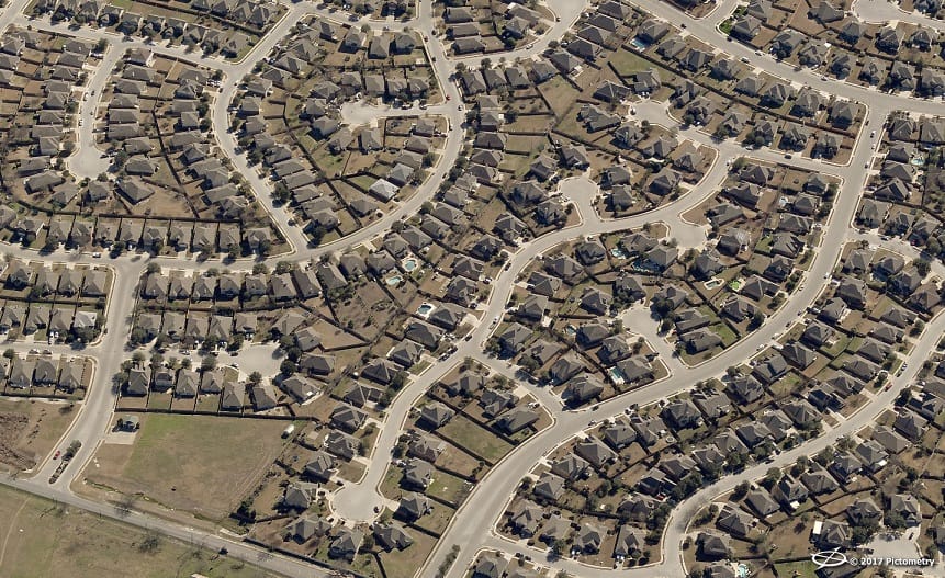
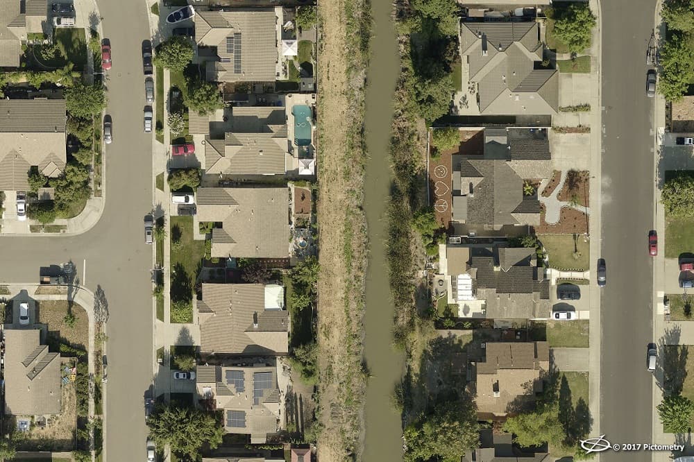
We are most well-known for the patented Pictometry® imagery, from which we can extrapolate property measurements and other key pieces of data. That property data is available in our desktop applications as well as EagleView Reports, which come with aerial images of the property and detailed roof and wall measurements.
Together, Pictometry imagery solutions and property data from EagleView answer questions about millions of residential and commercial properties across North America. Our solutions save county assessors, insurance adjusters, roofing contractors, and others time and money – cutting down on the number of field visits and manual measurements they need to perform. Further, we can reduce the exposure to risk inherent in climbing onto a roof or driving all over a city or county.
Simply put, the data EagleView derives from its Pictometry imagery transforms the workflows of commercial industries and government agencies alike.
Q: Please explain the relationship between EagleView and Pictometry imagery?
A: Back in 2000, a company called Pictometry formed in Rochester, New York. Later, in 2008, EagleView Technologies was founded in Bothell, Washington, just outside of Seattle. EagleView developed a method of deriving roof measurements from imagery – more specifically, from Pictometry imagery.
In 2013, Pictometry merged with EagleView Technologies, a provider of aerial roof measurements and property data reports. As of February 2017, the two operate under the name EagleView, with Pictometry imagery as an ingredient product brand.
 Recommended: BOLT Solutions: The Answer To Consumer Demand For Channel And Product Choice
Q: Which agencies and industries does EagleView serve?
A: EagleView provides a variety of products to serve the needs of different industries. We do business with government agencies, especially at the city or county level, in departments like assessment and appraisal, public safety, geographic information systems (GIS), and more. We also partner with the federal government and military.
Government agencies receive aerial imagery and gain access to it through our software. They can also upload the images to their own servers for offline access.
This has changed the workflows for property value assessors, for instance, who can spot property changes at their desks rather than drive around their jurisdiction. Public safety agencies use our imagery and data to gain information about incident locations before help arrives on the scene. Our technology has changed the way these agencies conduct their day-to-day operations.
We also offer several unique solutions to the private sector. The construction industry represents a large portion of EagleView’s business. Roofing contractors, for instance, can order EagleView property data reports directly from our website. We partner with roofing and construction supply distributors all over the United States to sell EagleView Reports and help contractors order materials through our EagleView CONSTRUCT™ platform. Solar contractors also use our data to determine azimuth and shade cover for specific properties.
The insurance industry is another segment we serve, including both underwriters and claims adjusters. EagleView offers a risk-management report to underwriters, so they can see a property’s condition before writing a policy. After an extreme weather event or other disaster, insurance adjusters can see both pre-event and post-event data detailing a property’s condition, measurements, and other features.
We also work with the energy infrastructure sector, providing corridor image capture, LiDAR, and other remote sensing solutions to allow oil and gas pipelines and electric utilities to better manage those assets.
Q: What products and services does EagleView offer?
A: Most of our customers know us for the patented Pictometry aerial imagery, which we capture with a fleet of 115 aircraft. We take our aerial imagery from multiple perspectives – both a top-down or orthogonal view and from 40- to 45-degree oblique angles in all four cardinal directions (north, south, east, and west).
From that imagery, we create our property reports. Our images are actionable, so we can derive exact measurement and location data from them. For instance, assessors use our ChangeFinder™ data to detect property changes over time.
When contractors and insurance carriers order our property data reports, they’re looking for information on the measurements of a property’s roof and walls as well as diagrams of that home. Insurance carriers in particular, whether for underwriting or claims, are looking for recent images that show property condition clearly.
We also offer additional imagery products:
• Our Pictometry AccuPLUS® solution, an add-on to our orthogonal imagery, provides seamless and authoritative aerial imagery that reduces feature lean and has been fully qualified and approved by the U.S. Geological Survey.
• Critical360® is our interior mapping and 3D model software designed with public safety and facilities management in mind. Using LiDAR and 360-degree panoramic photography, we construct a three-dimensional model and map of a building’s interior.
• Other products include LiDAR, 3D city models, four-band with near-infrared imagery.
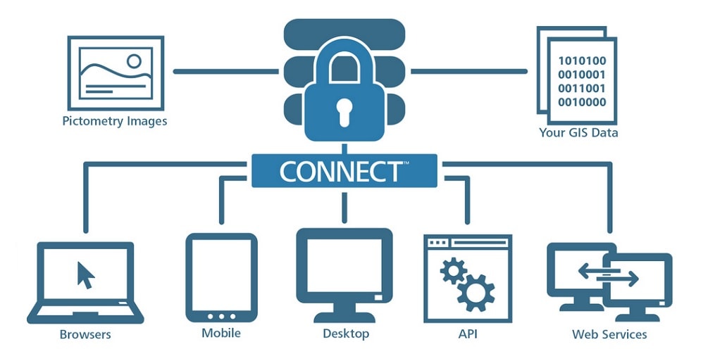
Our customers can access their aerial imagery and data through our applications, like CONNECTExplorer™, CONNECTAssessment™, and our mobile apps. Our imagery also integrates into other platforms. Esri® ArcGIS® is the most notable of these; others are industry-specific for computer-aided dispatch (CAD) and computer-aided mass appraisal (CAMA) software for E9-1-1 and assessors, respectively.
 Recommended: DeepMap Announces $25M Series A Round, Delivers A Better HD Mapping And Localization Platform
Q: What can we expect from EagleView in the next six months?
A: EagleView has long been dominant in the Insurance Claims space. We recently announced our EagleView OnSite™ solution that gives insurance adjusters post-event imagery and data. EagleView OnSite provides imagery and data from multiple camera sources, including drones, and delivers that information right to the claims adjuster’s desk.
We just acquired a company called OmniEarth which has machine learning technology that can rapidly identify features in images. The technology will allow us to enter the water resource management market, improve workflows for insurance underwriters, and deliver property change reports to county assessors much more quickly than we can today. You will see you actively integrating these new capabilities into all of our market solutions in the coming months.
 Recommended: PITSS Optimizes Business Processes By Modernizing Legacy Oracle Systems
Q: Finally, what is the company culture like at EagleView?
A: We pride ourselves on being a work-hard, play-hard kind of environment. We have offices in Rochester, NY, and Bothell, WA, and at both we have fully-stocked kitchens. Between these offices and including remote employees, we have more than 500 team members spread out across North America. We regularly host happy hours, and we have wellness programs running in Rochester and Bothell. Our employees are also known for having impromptu Nerf gun wars and ping pong tournaments.
That being said, the leadership team is always open to new ideas from employees. We regularly host all-hands meetings and other events to solicit feedback and rally our employees. Through monthly company-wide surveys, we’re always looking for ways to create an even more comfortable environment.
I’m happy to say we have very enthusiastic, team-oriented employees all across the company. This March in Rochester, we experienced a bad snowstorm. One member of our Photogrammetric team actually cross country skied to work – that’s dedication!
Activate Social Media: