
Thermopylae Sciences & Technology (TST) is a technology company specializing in geospatial applications, mobile frameworks, and location intelligence consulting. Thermopylae engineers have been working with Google as an Enterprise Partner for the past decade. Our award-winning partnership supporting Google Earth provides the engineering foundation for us to work alongside Google to introduce this exciting technology to the open-source world. Thermopylae engineers are currently working to ensure the GEE suite transition to open-source is a smooth one and that the codebase is ready for public use. Below is our interview with Andres Terrazas, Chief Technology Officer of Thermopylae Sciences & Technology:

Q: What has Been Google Earth Enterprise’s Trajectory up to this Point?
A: Back in 2006 Google released their Google Earth Enterprise (GEE) offering to allow organizations and businesses to take advantage of the same publicly available Google Earth capabilities, behind the firewall, in an offline/disconnected environment, or in low bandwidth region.
Google Earth Enterprise afforded businesses and organizations the ability to build their own globes with their own imagery, terrain, and content assets and share them with everyone in the organization. This was significant for industries like utilities, mining, agriculture, transportation, energy, as well as the largest organizations: the federal government, defense/intelligence and state & local offices.
For almost 10 years Google Earth Enterprise allowed developers to build and host their own private maps and 3D globes. GEE Fusion, Server, Client, and Portable products gave users the ability to process, present, and analyze geospatial content in a very intuitive way. However, in March 2015, Google decided that it would retire the Google Earth Enterprise suite but continue support until March 2017. There was no clear public explanation as to the reason for the deprecation, but we know Google is focusing their resources on strategic cloud initiatives. Google’s goal is to have the most powerful cloud services, Google Cloud Platform (GCP), and is offering their high-resolution orthoimagery sets along the way.
After almost two years of updates; primarily maintenance fixes, Google announced that on March 22, 2017 it would open-source their Google Earth Enterprise product, consisting of GEE Fusion, GEE Server, and GEE Portable. The GEE Client will continue to be supported and made available along with providing an obfuscated version of the current Google Maps and Earth API. During the past two years Google observed how mission-critical GEE had become to internet disconnected customers that required privately hosted globes. Over many a lunch at the Google cafeteria’s our engineers discussed the criticality of GEE and ideas on ensuring users were taken care of. Many industries heavily leverage the GEE stack to support globes on private networks and will continue to do so into the future. This is a requirement that will always exist for some very critical industries.
Currently, our engineers that never gave up on GEE are hard at work supporting the stack’s path to an open-source release on Github in March of this year. This means the GEE story doesn’t end here. As engineers, we envision it evolving as an enabling component of other open-source world initiatives, with many chapters still to be told.
 Recommended: Uberkit Helps Uber Drivers To Grow Income In The Rideshare Market
Q: What is Being Open-Sourced?
A: The three main components provided in the GEE OS package in order of process flow include: Google Earth Enterprise Fusion, Google Earth Enterprise Server, and Google Earth Enterprise Portable. All three products work together seamlessly to provide the user a way to process, present, and analyze rich GIS data in various configurations and environments: client/server and client/disconnected local server.
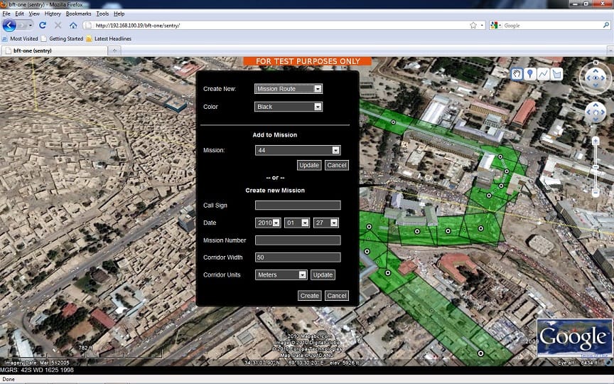
Google Earth Enterprise (GEE) Server is the cornerstone of the GEE suite. GEE Server allows you to store and process terabytes of imagery, terrain, and vector content on your own server infrastructure behind or infront of the firewall. GEE Server provides a way to serve 3D globes and 2D maps and consume them with a desktop client (GEE Client) or a web-client using the Google Earth and Google Maps APIs. In addition, GEE Server supports the OGC Web Map Service (WMS) standard. WMS provides a standard HTTP/S interface to request map images from one or more published geospatial databases.
Google Earth Enterprise Fusion is the component that allows developers in organizations to build custom Google Earth Globes and Google Earth maps using their own imagery products. The Fusion product works hand-in-hand with GEE Server to host rich geospatial data. Fusion allows you to integrate your own data image files and publish the resulting database to GEE Server. Once published to GEE Server, customers and internal users can access the geospatial content in either 3D or 2D via Google Earth Enterprise Client (EC) on their desktop or on the web via the Google Maps and Google Earth APIs.
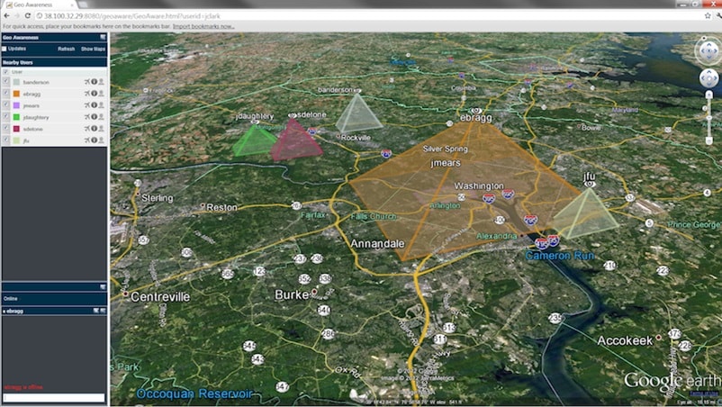
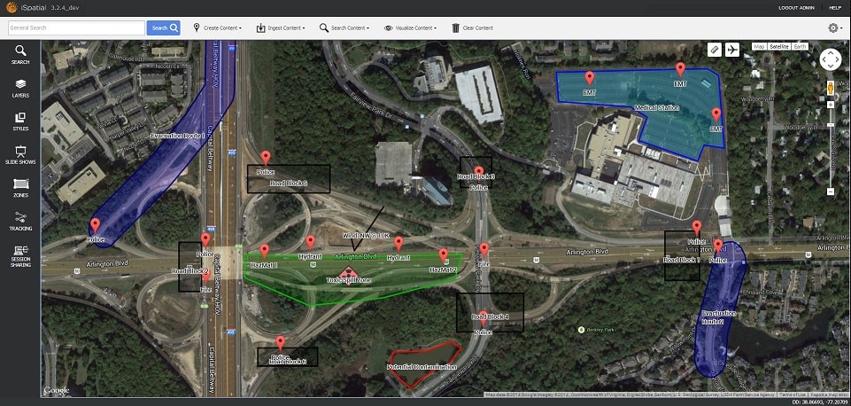
Google Earth Enterprise Portable is the component of the stack that allows users and customers to access their geospatial data in the field in a client/disconnected local-server configuration. The GEE Portable product is composed of two distinct applications: globe cutter and portable server.
The globe cutter tool, installed on the GEE Server, allows end-users and administrators to select an area of interest, cut that area into a package, and download it as a portable globe file. This allows users to take a much more compact and relevant portion of the globe for deployments and field operations.
The other application provided by GEE Portable is the actual portable server. The portable server can be installed on Windows or Mac OS X in single-user mode. With the portable file and portable server in hand the user can operate in a completely offline mode and still be able to analyze rich geospatial data for their area of interest anywhere in the world. This offers a very useful solution for soldiers deployed in limited communication areas or field engineers surveying land parcels for potential site locations.
 Recommended: FutureProof Retail – The Self-Checkout Software Makes Store Shopping Much Faster
Q: What is Not Being Open-Sourced?
A: Google Earth Enterprise Client (EC) will not be open-sourced but will continue to be supported. The Google Maps API implementations will likewise not be open-sourced but included in an obfuscated manner. The Google Earth API implementation will not be open-sourced either. With the challenges facing the Google Earth Plug-in, it might as well be considered deprecated at this point. Open-sourcing the Google Earth API would only shift the current problem Google is facing with browsers moving away from the NPAPI specification to the the open-source community. It is certain that new blood in the API space will come to fill the gap in the very near future.
 Recommended: GUI Test Automation Squish Tool Suite Delivers Reliable And Proven Solutions For Test Automation
Q: What Does this Mean for the GIS community?
A: It was understable that GIS users were nervous and looking for answers in late 2014 when Google ominously announced that it would end support for the Google Earth plug-in, followed later in 2015 by ending support for Google Maps Engine, and finally culminating with the news that Google Earth Enterprise would be deprecated altogether. With a looming depreciation date of March 22, 2017, an assessment and transition plan was required. Various vendors scrambled to provide transition paths from their GEE to a new stack.
Fast-forward to 2017 and the GIS landscape is looking a lot more promising. Options are good! Now with just a couple of months before the Google Earth Enterprise platform is open sourced, the GIS community has some additional options to look forward to.
 Recommended: “Engagement” The Most Important Metric For Any Software Company
Q: So What?
A: The reason this is exciting for the GIS community is that the Google Earth Enterprise suite provides one of the most fully-featured solution available,remarkably integrated to provide even GIS novices a way to process, present, and analyze rich GIS data in a familiar and intuitive manner. A lot of the à la carte open-source options listed above independently work well, but require customers to cobble together their own stack of components. Some might prefer to tinker and integrate while others will benefit from being able to deploy a full stack without researching a sea of open-source alternatives. You get a familiar best of breed solution all in one place. Also, Google is releasing the Google Earth suite under the Apache 2.0 license which frees up the open source community to anybody to modify to their heart’s content! With a very large user community still utilizing GEE within critical IT infrastructure, continued support and future enhancements are a boon that will give them the freedom to operate well into the future.
Although open-sourcing is exciting there are some things that the community will have to address early on. GEE has a handful of third party libraries that will need replacement to provide a fully open source package. Identifying those and plugging in solid alternatives will be important. There are a variety of emerging map APIs that provide 2D and 3D functionality, which will open up a new world of possibilities for GEE serving up rich 3D experiences.
Although Google will not provide an official SaaS solution around GEE open-source, the possibility of setting one up is very feasible. Purchasing Google high resolution imagery and data sets and using them in the cloud is possible and now made even easier by hosting them in Google Cloud Platform (GCP) Buckets. Buckets are basic containers that hold data in Google Cloud Storage. Standing up the GEE suite in the cloud does not involve a heroic effort. Within the Google Compute Engine (GCE) you can provision a virtual machine (VM) and deploy both GEE Server and Fusion. GCE allows you to scale these servers as needed. You can access the imagery in your GCP Bucket and fuse it to a new globe using GEE Fusion. You can now leverage both Google’s computing power and imagery using a fully scalable architecture.
One of the criteria that organizations use to decide whether to leverage an open-source product is to gauge its longevity and stability. A good proxy for these two attributes is to measure the strength of the open-source community around it. The good news with GEE is that it’s already off to a great start. Thermopylae Sciences & Technology is committing multiple engineering teams with current access to the codebase to future sustainment. We are coordinating with other Enterprise Partners that supported GEE, sold GEE licenses, provided custom implementations with imagery fusion services and general support around the product to ensure global support options are available. Accounting for any proprietary third-party libraries that might hinder the community project moving forward and applying rigorous testing will ensure its stability. Interest in integrating with and participating in the effort is growing from companies and individuals alike. The outlook for GEE open-source is promising with a vibrant community coming together to support it with long-term commitments of engineering and expertise.
Activate Social Media: