
Headquartered in Tokyo, with ten branches scattered throughout Japan and Australia, Terra Drone utilizes the finest laser and photo surveying methods through its drones, creating a high-quality 3D mapping, and providing essential tools for construction management both within and outside Japan. To find out more about their drone technology we sat down with Kota Kandori, Country Director at Terra Drone Australia:

Q: Tell us something more about Terra Drone Corporation?
A: Featured is our original drone technology, high-security quality, high-speed data analysis, reflexive response, and cutting-edge software. Our targeted clients for the ideal business are major construction companies, civil engineering, and land surveying companies. To date, we have had greater than 400 UAV surveying projects completed, Our drones are completely programmable and have the capability to continue a flight sequence for 2 hours autonomously. In the field of drone management systems (UTM), we have partnered with Unifly and developing a flight management system that is truly next generation. Our group company, Terra Motors, manufactures and sells innovative electric-motor bicycles and tricycles in Asia. Sales figures are above 30,000 individual units per year and control 85% of the overseas sales ratio.
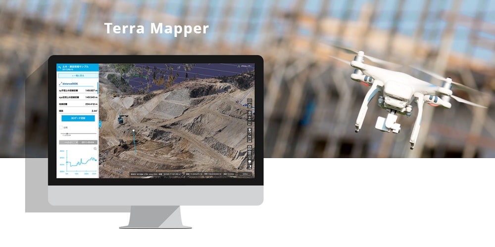
Q: You’ve recently launched your image processing software “Terra Mapper”; could you tell us something more?
A: Terra Mapper is image processing software designed to assist drone surveying services. Terra Mapper is an automated drone navigation, image processing, and 3D image analysis program. It can be utilized on its own, rather than requiring the use of multiple different supplementary software. Terra Mapper enables users to accurately inspect the 2D & 3D data images produced by their nominated drone service, allowing effective analysis at a more cost-efficient price. Terra Mapper has the ability to universally process, analyze and share all types of data from flight to ground. Running Terra Mapper can cost as low as 1/5 when comparing to other software. The design is simplistic, the operation is with ease, and analysis in-depth. Terra Mapper can be utilized in a variety of industries such as surveying, mining, agriculture, inspection, real estate, general insurance and more! For instance, realtors can create customised 3D models to share with clients or advertise your business. With Terra Mapper, you can create an interactive and attractive website especially in comparison to 2D modeling For general insurance, by using a Terra Mapper, investigators are able to conduct a dynamic risk assessment from a distance while also capturing the evidence that required with stills and videos.
 Recommended:
 Q: What advantage does Terra Drone have over its competitors?
A: By exploiting the knowledge and know-how we have accumulated over the completion of the 400 drone surveying projects, we also offer ongoing support to users, helping them perform photogrammetry survey and offering training service such as Drone flight training, Image processing software training (Terra Mapper), Drones buying guide and so on. In addition, we offer LiDAR solution and UTM.
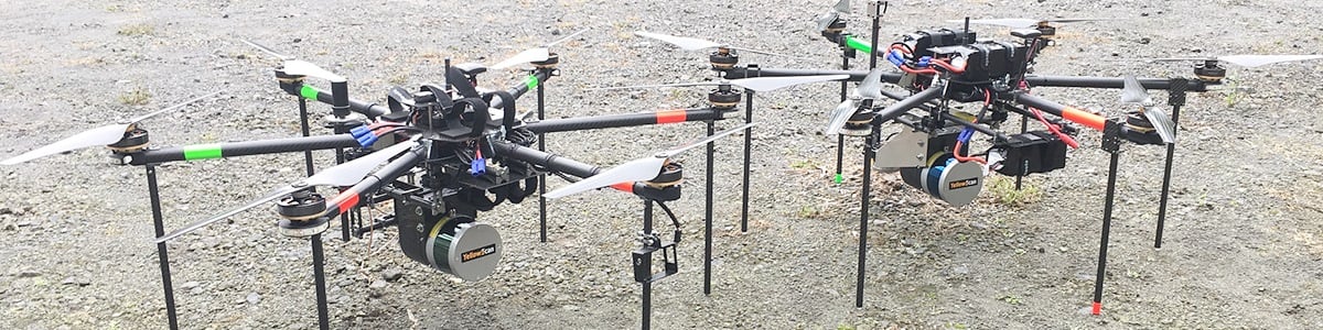
LiDAR Solution-Terra Drone provides the aerial LiDAR survey solution that is customised for each industry. Our LiDAR solution can reduce the time, cost and complexity of inspections and surveying, and enables you to capture Digital Elevation Model even with vegetation or other obstacles. With our SLAM system (Simultaneous Localization and Mapping), drones navigate over the terrain without GPS – indoors as well as outdoors.
UTM (UAV Traffic Management) – Terra UTM(Unmanned Traffic Management) consists of FOS(Flight Operation System) which enables simultaneous remote operation of multiple drones, which will help improve the efficiency of work activities using drones.Terra UTM enables Beyond Visual Line Of Sight (BVLOS) mission planning and deployment.
With these services, we can consult individual solution depending on customers’ needs.
Q: What were the main challenges you faced in developing the company?
A: The biggest challenge we faced was a lack of employees with skill sets and key management personnel. It took time to create the company culture and assimilate all of these individuals. Now, a lot of talented people have joined having the same vision.
 Recommended: DevSecCon Offers Knowledge And Learning Opportunities For People Working In Development, DevOps And Security
Q: What can we expect from Terra Drone in next six months?
A: We see our business growing rapidly all over the world. It’s been only 1 and a half year since we started our business, but we already have 7 branches in Japan, three branches in Australia and 1 branch in Indonesia. We will be expanding our business to the US, China, Europe and more. We provide innovative industrial solutions from the sky.
Activate Social Media: